Difference between revisions of "Data sources"
From OpenCellID wiki
(→Android smartphone apps) |
|||
| Line 10: | Line 10: | ||
! scope="col" class="unsortable" width="25%"| Download | ! scope="col" class="unsortable" width="25%"| Download | ||
! scope="col" class="unsortable" width="35%"| Comment | ! scope="col" class="unsortable" width="35%"| Comment | ||
| + | |- | ||
| + | | title="Name" | [http://wiki.openstreetmap.org/wiki/OsmPadxx OpenCellID] | ||
| + | | title="Screenshot" | http://wiki.openstreetmap.org/w/images/thumb/3/37/OsmPad.png/120px-OsmPad.png | ||
| + | | title="Description" | mapping of house numbers by defining the exact position of the house number tag with the help of an integrated map | ||
| + | | title="Download" | play | ||
| + | | title="Comment" | xx | ||
|- | |- | ||
| title="Name" | [http://wiki.openstreetmap.org/wiki/OsmPadxx OpenCellID] | | title="Name" | [http://wiki.openstreetmap.org/wiki/OsmPadxx OpenCellID] | ||
Revision as of 02:35, 7 January 2014
This page lists a number of smartphone apps that allow to contribute GSM cell tower measurements to the OpenCellID database.
Android smartphone apps
| Name | Screenshot | Description | Download | Comment |
|---|---|---|---|---|
| OpenCellID | 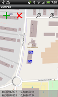
|
mapping of house numbers by defining the exact position of the house number tag with the help of an integrated map | play | xx |
| OpenCellID |
|
mapping of house numbers by defining the exact position of the house number tag with the help of an integrated map | play | xx |
| OpenCellID |
|
mapping of house numbers by defining the exact position of the house number tag with the help of an integrated map | play | xx |